
Research Outcomes
Dynamical Systems of Hazards and Society
Socio-hydrology, and the study of the interconnected relationships between people and water, has been a rapidly growing field of study in the past two decades. To build on the knowledge gained from previous projects, we are exploring how proxies for adaptive capacity, natural hazards, infrastructure, disaster relief, and mitigation investment can be modeled to forecast community recovery trajectories under a variety of scenarios. We are testing how various response mechanisms can inform various “policy approaches” and if it is possible to empirically inform such dynamical systems models.

Flooded highway during Hurricane Harvey
Using Daily Satellite Imagery to Detect Multi-Hazard Events
I am currently developing a method that uses daily satellite imagery from the last decade to detect multi-hazard events across the continental US. One of the major contributions this work will have to the multi-hazard community are the improvements we are making to detecting flood related hazards. Since the majority of historic satellite based flood detection methods rely on optical sensors, cloud coverage and ground noise can make it difficult to develop water masks. Our topographic downscaling algorithm for the MODIS NRT Flood Product and the use of NOAA's precipitation frequency has enabled us to better delineate flood hazards from the existing repository of satellite imagery. Combined with other hazards (e.g., heat and/or air quality events), we are detecting how multi-hazard events have transformed over time.

Hurricane Harvey over Houston, Texas on August 25th, 2017
Critical Resource Accessibility during Extreme Flood Events
Building off the idea that vulnerable populations are exposed to flooding at a higher rate, this project examines how access to critical resources (e.g., grocery stores, hospitals, fire stations, etc.) changes as a storm progresses. Using our near-real-time urban flooding model, we developed a network routing algorithm that quantifies different resiliency metrics for households traversing roadways to get to available resources they may need during and immediately after a flood event. The model is completely built on open-source and accessible data, meaning this model can be applied virtually anywhere that OpenStreetMap data is available. For our specific study, which examined Austin, Texas, we were able to highlight how the most vulnerable quarter of the population carries a significantly greater burden of a flood's impact in terms of resource accessibility disruption compared to other parts of the population.

Resource accessibility model outputs including network and household scale redundancy and reliability metrics
Near-Real-Time Urban Compound Flooding Impact
In this project we examined how urban compound (pluvial and fluvial) flooding impacts vulnerable populations. We developed a methodology to combine different near-real-time flood estimate workflows with a social vulnerability index (SVI) to create an accessible flood impact metric. The takeaways from our findings include:
-
Flood hazard and vulnerability can be combined in near-real-time to estimate flood impact
-
Pluvial flood drastically increases the number of people exposed to a flood event
-
Aggregating flood hazard results can misrepresent who is impacted by a flood event

Flood Impact for the Austin, Texas during the 2015 Memorial Day Flood

Coding Products
SVInsight
Social Vulnerability Indices, or SVIs, are metrics built on social and demographic information. Popular SVIs have been around for over 20 years, and continue to play an important role in identifying at risk populations. We developed an open source SVInsight is a python package that creates SVIs for user defined areas using two popular approaches: a Factor analysis method and a rank method. Estimates are based on data from the American Community Survey 5-Year Results from the US Census. For more information, check out our GitHub repository and SVInsight website.
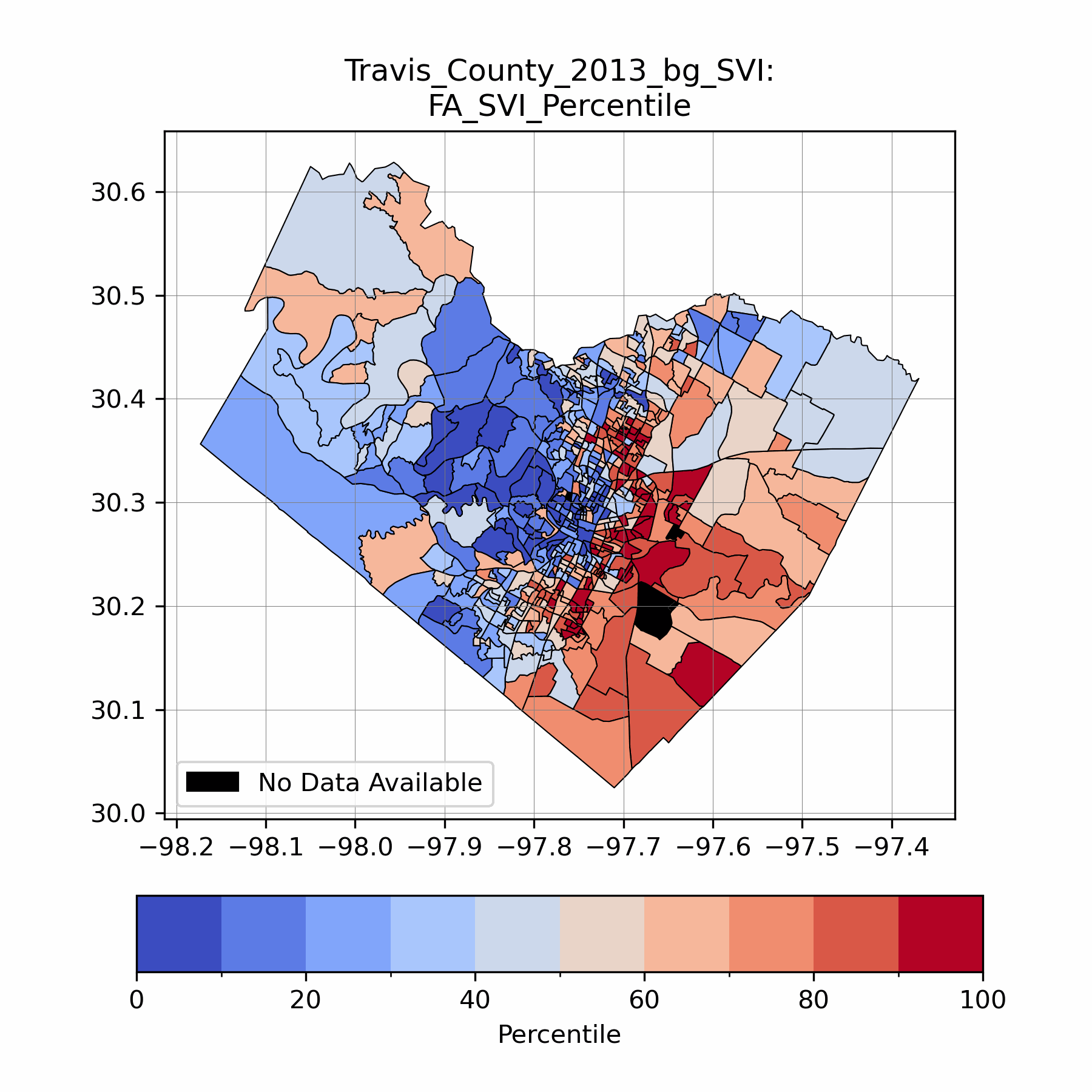
Time series social vulnerability estimate for Travis County, Texas using SVInsight
PyGeoFlood
GeoNet and GeoFlood are Python tools to extract channel networks from topographic surfaces and create elevation based fluvial inundation estimates using the Height Above Nearest Drainage (HAND) method. Currently, both tools are undergoing redevelopment. Some of the planned improvements include:
-
Refactor to be object oriented and create a single pip-installable package
-
Adding pluvial and coastal flooding components
-
Increase documentation and overall usability
-
Create a plotting and evaluation module
-
Develop deployable near-real-time inundation estimation tool for user defined areas
This project is under active development. To learn more go to the PyGeoFlood Github repository.

Example GeoFlood fluvial inundation example for Shoal and Hancock Creeks in Austin, Texas

Program Participation
Below you will find a few of the prominent programs that my work has contributed to.
SETx UIFL
Role: Graduate Researcher
The Southeast Texas Urban Integrated Field Lab (SETx-UIFL) is one of four Urban Integrated Field Laboratories (UIFLs) awarded in Fall 2022 by the Biological and Environmental Research Program, Office of Science, U.S. Department of Energy. The UIFLs advance the sciences of climate, environmental, ecological, and urban change affecting heterogeneous urban regions to inform and develop sustainable, resilient, and equitable solutions. The SETx-UIFL focuses on Southeast Texas, specifically the Beaumont-Port Arthur Metropolitan Statistic Area (MSA). This economically significant region represents many urban centers along the Gulf Coast characterized by the population diversity and vulnerability, and ecological richness as well as climate adaptation needs.
Planet Texas 2050
Role: Graduate Researcher
Planet Texas 2050 researchers are committed to developing programs, tools, and policy recommendations that will improve Texas’ adaptability and build its resilience. To do that, we have created a set of innovative and interdisciplinary projects that leverage the talents and expertise of our research network to tackle critical issues when it comes to helping Texas respond to rapid growth and climate change.

ATX NASA Climate Atlas
Role: Graduate Researcher
The City of Austin, TX (ATX) wants to strategically address equity and environmental justice (EEJ) through climate resiliency and infrastructure investment options. This strategic path has challenges. One important being, prioritizing the neighborhoods where investments are made relative to the hotspots of environmental stresses they experience. Our project partner, Go Austin/Vamos Austin (GAVA), has compiled information and experiences that show the disproportionate environmental extremes the historically underserved neighborhoods face and the additional costs they incur due to rising housing prices and associated cost of living. This data integration project combines municipal policy analysis, local community experiences and independent geospatial data from academic teams to provide a more effective means for the City to undertake EJ decisions.
